
DOST-PHIVOLCS has shared a public advisory about the Taal volcano hazard maps and lists of barangays prone to Taal Base Surge, Taal Volcanic Tsunami, and Taal Ballistic Projectile. Hazard Maps • Taal Volcano Base Surge Hazard Map • Taal Volcano Tsunami and Fissuring Hazards Map • Taal Volcano Ballistic Projectiles Hazard Map You may click on the links below to download the high-res images. With the help of volunteer mappers and the Batangas Public Information Office, Google Philippines has made a map of evacuation centers regarding the Taal Volcano eruption. You may find the Taal Volcano Eruption Crisis Map here. You may also search for the Crisis map by following these steps: Search "Taal Volcano" on Google. Read more in our articles including "Taal Volcano Hazard Maps and List of Prone Barangays" and "Google launches Taal Volcano Eruption Crisis Map".
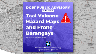
DOST-PHIVOLCS has shared a public advisory about the Taal volcano hazard maps and lists of…
Jul 2, 2021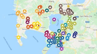
With the help of volunteer mappers and the Batangas Public Information Office, Google Philippines has…
Jan 16, 2020
Insta360 has officially launched the Luna Ultra in the Philippines. The camera is co-engineered with…
Jun 24, 2026
After being spotted in Lazada, the Infinix HOT 70 is now available in the Philippines.…
Jun 24, 2026
Google has announced new updates to Chrome Autofill. With this feature, it brings support for…
Jun 24, 2026
The Cybercrime Investigation and Coordinating Center (CICC) has ordered the temporary blocking of the game…
Jun 23, 2026DOST-PHIVOLCS has shared a public advisory about the Taal volcano hazard maps and lists of barangays prone to Taal Base Surge, Taal Volcanic Tsunami, and Taal Ballistic Projectile. Hazard Maps • Taal Volcano Base Surge Hazard Map • Taal Volcano Tsunami and Fissuring Hazards Map • Taal Volcano Ballistic Projectiles Hazard Map You may click on the links below to download the high-res images.
With the help of volunteer mappers and the Batangas Public Information Office, Google Philippines has made a map of evacuation centers regarding the Taal Volcano eruption. You may find the Taal Volcano Eruption Crisis Map here. You may also search for the Crisis map by following these steps: Search "Taal Volcano" on Google.
Our coverage of Taal Volcano includes: "Taal Volcano Hazard Maps and List of Prone Barangays"; "Google launches Taal Volcano Eruption Crisis Map"; "Insta360 Luna Ultra launched, priced in the Philippines". Each article provides unique insights and information.