
With the help of volunteer mappers and the Batangas Public Information Office, Google Philippines has made a map of evacuation centers regarding the Taal Volcano eruption. You may find the Taal Volcano Eruption Crisis Map here. You may also search for the Crisis map by following these steps: Search "Taal Volcano" on Google. DOST-PHIVOLCS has shared a public advisory about the Taal volcano hazard maps and lists of barangays prone to Taal Base Surge, Taal Volcanic Tsunami, and Taal Ballistic Projectile. Hazard Maps • Taal Volcano Base Surge Hazard Map • Taal Volcano Tsunami and Fissuring Hazards Map • Taal Volcano Ballistic Projectiles Hazard Map You may click on the links below to download the high-res images. Read more in our articles including "Google launches Taal Volcano Eruption Crisis Map" and "Taal Volcano Hazard Maps and List of Prone Barangays".
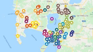
With the help of volunteer mappers and the Batangas Public Information Office, Google Philippines has…
Jan 16, 2020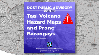
DOST-PHIVOLCS has shared a public advisory about the Taal volcano hazard maps and lists of…
Jul 2, 2021
Francisco Motors has launched the Elektron, its first fully electric passenger vehicle, with prices starting…
Jul 28, 2026
Smart Communications has partnered with cloud gaming provider Blacknut to give Smart and TNT subscribers…
Jul 28, 2026
The Luzon Cluster 1 of the Department of Information and Communications Technology (DICT) has launched…
Aug 11, 2020
Garmin has officially launched the CIRQA Smart Band in the Philippines, expanding its lineup of…
Jul 27, 2026With the help of volunteer mappers and the Batangas Public Information Office, Google Philippines has made a map of evacuation centers regarding the Taal Volcano eruption. You may find the Taal Volcano Eruption Crisis Map here.
You may also search for the Crisis map by following these steps: Search "Taal Volcano" on Google. DOST-PHIVOLCS has shared a public advisory about the Taal volcano hazard maps and lists of barangays prone to Taal Base Surge, Taal Volcanic Tsunami, and Taal Ballistic Projectile. Hazard Maps • Taal Volcano Base Surge Hazard Map • Taal Volcano Tsunami and Fissuring Hazards Map • Taal Volcano Ballistic Projectiles Hazard Map You may click on the links below to download the high-res images.
Our coverage of Taal Evacuation Centers Map includes: "Google launches Taal Volcano Eruption Crisis Map"; "Taal Volcano Hazard Maps and List of Prone Barangays"; "Francisco Motors enters EV Market with Elektron SUV". Each article provides unique insights and information.