infinix x yugatech

Google Camel: Google Maps Street View for the Desert

Listen to article

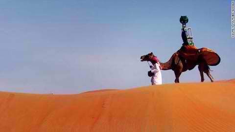
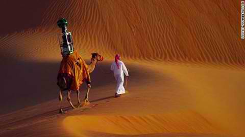
Will Google’s very high tech way to map cities, streets and space, it chose the most conventional solution to map vast amounts of desert land. It’s called Google Camel.


We’ve normally see the multi-camera setup on top cars along EDSA (spotted one last year here) in January this year when Google formally introduced Street View in the Philippines.

google-streetview-camel

We’ve also seen the Trekker which can be mounted at the back of a person like a backpack (Google used this to map a walking tour of Intramuros).

For other regions like the desert, Google picked a camel. It’s the first animal they’ve used to do such a task.

google-camel

{via CNN}

React to this article:
Written by
Abe Olandres

Abe Olandres

Editor-in-chief

Abe is the founder and Editor-in-Chief of YugaTech with over 20 years of experience in the technology industry. He is one of the pioneers of blogging in the country and is considered by many as the Father of Tech Blogging in the Philippines.

View all posts by Abe Olandres →

6 Comments

A
a · 12 years ago

E kailan pa matatapos iyan?

Reply
SY
syntaxerror · 12 years ago

*desert

Reply
NA
Name: bilbo · 12 years ago

ungas!!!!!
dito na spelling police

Leave a Reply

Loading next article...