DTI-GIZ, under the Private Sector Promotion Program (SMEDSEP), came up with this pretty neat Google Mapping project to map the whole island of Bohol and all of its 700+ tourist sites and tourism-related establishments. The map was collected using Samsung Galaxy Tab running Open Data Kit (ODK) applications. This is like your ultimate travel guide to Bohol. You can see the complete mapping project here: bit.ly/boholtourismmap Pretty good job, IMO. Now can we have the rest of the islands of the Philippines mapped like that too? Nokia has recently announced its latest mapping service called HERE - a new and improved cloud-based location brand and platform. Nokia can be considered a veteran when it comes to mapping. All current Nokia Maps features are still included but with the addition of other cool stuff like: Collections - allows you to save locations to your Nokia account and sync them across your devices so you can view them over the web or on your smartphone. Read more in our articles including "DTI maps entire Bohol Tourist Site with Galaxy Tabs" and "Nokia announces new mapping service "HERE"".
DTI-GIZ, under the Private Sector Promotion Program (SMEDSEP), came up with this pretty neat Google…
Jul 27, 2011Nokia has recently announced its latest mapping service called HERE – a new and improved…
Nov 15, 2012
Google’s 2025 Year in Search highlights the topics that captured the attention of the Philippines…
Dec 14, 2025
It looks like the Philippines has retained its third place position in Pornhub traffic. This…
Dec 14, 2025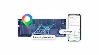
Google Maps reveals new AI features powered by Google Gemini. These are Ask Maps and…
Mar 13, 2026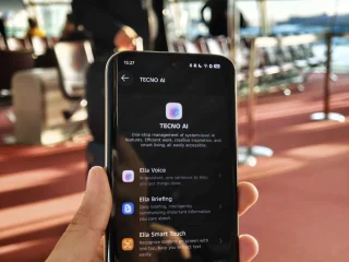
TECNO emphasized its “Practical AI” ambition for emerging markets by announcing increased AI investment plans…
Mar 2, 2026DTI-GIZ, under the Private Sector Promotion Program (SMEDSEP), came up with this pretty neat Google Mapping project to map the whole island of Bohol and all of its 700+ tourist sites and tourism-related establishments. The map was collected using Samsung Galaxy Tab running Open Data Kit (ODK) applications.
This is like your ultimate travel guide to Bohol. You can see the complete mapping project here: bit.ly/boholtourismmap Pretty good job, IMO. Now can we have the rest of the islands of the Philippines mapped like that too?
Our coverage of bohol map includes: "DTI maps entire Bohol Tourist Site with Galaxy Tabs"; "Nokia announces new mapping service "HERE""; "Google Year in Search 2025 for Philippines revealed". Each article provides unique insights and information.