
If you own a smartphone, then the chances are that you have encountered or used its satellite navigation features, which most of us commonly refer to as GPS. But the GPS is just one of the satellite navigation systems that smartphones use, and if you’re wondering what they are and want to make sense of it, then read on to find out.
GPS (United States of America)
The Global Positioning System or GPS, originally Navstar GPS, is the most popular satellite navigation system for military and civilian use, and as the name suggests, operates globally. It is owned by the United States government and operated by the U.S. Air Force Space Command (AFSPC). Its first launch was in February 1978, so the system has been around for quite a while. Don’t worry though, as the Air Force launches new satellites to replace aging ones when needed. As of October 18, 2018, there were a total of 31 operational satellites in the GPS constellation.
A-GPS

The Assisted GPS or Augmented GPS (A-GPS or aGPS) is different from the other systems on the list, as it works in tandem with a GPS. Compared to standalone or self-ruling GPS devices that depend solely on information given by satellites, an A-GPS equipped device like the smartphone uses cell tower data to enhance its quality and precision. This allows location-based services to quickly pinpoint your location when there’s poor satellite signal like indoors.
GLONASS (Russia)

While the U.S. has GPS, Russia has the Globalnaya navigatsionnaya sputnikovaya sistema or “Global Navigation Satellite System” or GLONASS. Like the GPS, the GLONASS is used for military and civilian purposes. The development of GLONASS began in the Soviet Union in 1976 and launched numerous rockets since October 12, 1982. It consists of 24 satellites in orbit (plus three spares) for full global coverage.
BDS (China)

Next, we have China and their BeiDou Navigation Satellite System (BDS) which first launched on October 30, 2000. It started with three satellites with Beidou-1 and served mostly users in China and neighboring regions. China decommissioned Beidou-1 at the end of 2012 and moved on to Beidou-2 with ten satellites in orbit. In 2015, China launched the Beidou-3 with 23 satellites in orbit with the intention to provide global coverage in 2020 with a constellation of 35 satellites.
QZSS (Japan)

The Quasi-Zenith Satellite System (QZSS) is a project of the Japanese government and operated by the Japan Aerospace Exploration Agency (JAXA), with an aim to be a satellite-based augmentation system (SBAS) for the U.S. GPS to be receivable in the Asia-Oceania regions, with a focus on Japan. The first Quasi-Zenith Satellite (QZS-1) launched on September 11, 2010. In 2017, the Japanese government launched three more on separate occasions, the QZS-2, QZS-3, and QZS-4, bringing the total to four. Japan intends to bring the total number up to seven after 2018.
GNSS (European Union)

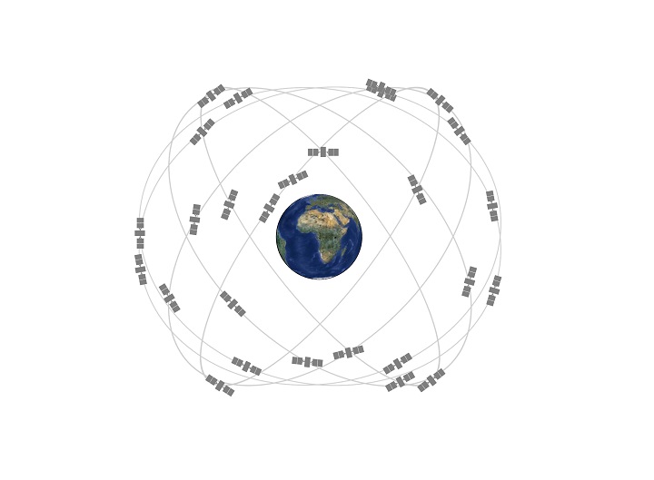
The European Union (EU) wanted to have their own independent high-precision positioning system, so they do not have to rely on the U.S. GPS Russian GLONASS, or Chinese BeiDou. So in 2011, they launched Galileo which is a global navigation satellite system (GNSS), operated by the European GNSS Agency (GSA) and the European Space Agency (ESA). As of July 2018, it has a total of 26 satellites in orbit with global coverage and used for civilian and commercial purposes. The complete 30-satellite Galileo system (24 operational and 6 active spares) is expected by 2020.
IRNSS (India)

India has the Indian Regional Navigation Satellite System (IRNSS), with an operational name of NavIC or Navigation Indian Constellation. It is operated by the Indian Space Research Organisation (ISRO) and mostly covers India for military and commercial purposes. The system was developed partly because access to foreign government-controlled global navigation satellite systems is not guaranteed in times of conflict or war. The Indian government approved the project in May 2006 and launched its first satellite on July 1, 2013. It currently has a total of seven satellites in orbit.
As you might have noticed, these satellite navigation/positioning systems vary based on the country that operates them. Since smartphones are used globally, it is only logical that these devices are compatible with these systems, so location-based apps like Google Maps and Waze work properly. Not all smartphones support all systems, though, but if yours does, then you can now appreciate it even more.


0 Comments
Leave a Reply