
In collaboration with the Department of Health (DOH) and Department of Transportation (DOTr), Google Maps incorporates COVID-19-related information to help the public in fighting the pandemic.
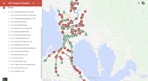
Embedded on its mobile and web versions, people may now see the 19 routes for shuttle services provided by DOTr for frontliners. Included in the list are routes around Metro Manila, Bulacan, and Laguna. This allows health professionals to find their way and estimate their travel time. Also reflected on the platform are schedule and route updates.
How to use it
Step 1: Open Google Maps via mobile or web.
Step 2: Enter your destination.
Step 3: Tap “Directions”.
Step 4: Select the train icon which comes after car and motorcycle icons to see a recommended route which uses the DOTr’s hospital shuttle routes, when available.
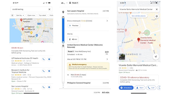
The new feature also shows nearby DOH-certified, COVID-19 testing centers and hospitals when users type “COVID testing” on Google’s search bar. Take note that individuals who are experiencing COVID-like symptoms must refer to the DOH’s Screening Tool or call (02-894-COVID / 02-89426843) before going to the hospital for guidance.
Google will also provide USD 5M worth of Search ads credits to Philippine government agencies, including DOH among others, to help in the propagation of credible and useful COVID-19-related information.


0 Comments
Leave a Reply